Toolkit · Wayfinding
Campus Map
A web 3D site model with occlusion-aware markers.
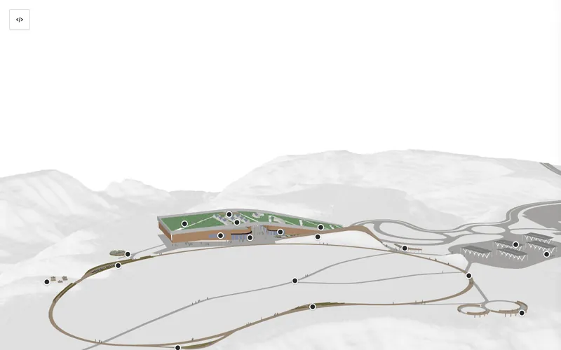
The problem
Architectural models arrive as hundreds of megabytes of geometry that no visitor will ever wait to download, so most institutions fall back to a flat illustrated map.
How it works
A processing pipeline converts the source model to binary, collapses scattered nodes into GPU instances, and applies geometry compression. Points of interest live in a separate file and can be edited visually.
Worth knowing
338 MB of source geometry became a 7.7 MB delivered file — roughly 102,000 scattered nodes collapsed into GPU instances, then compressed.
The clever part is the markers. Labels hide when a building or a berm blocks the line of sight, which normally requires a raycasting engine. Instead it uses a precomputed heightfield of about 145 KB — the occlusion is calculated once at build time rather than sixty times a second in the visitor's browser.
Using it at your organization
- The model is obviously yours to supply; the pipeline is documented.
- Points of interest are fully externalized, with a visual editor for placing them.
- Large source files need Git LFS and are excluded from the published site.
Stack: Google model-viewer · Draco compression · Git LFS · GitHub Pages
Licence: MIT — use, modify and redistribute freely, commercially or not.
Hosting: static files; no server required.
Related tools

Built for the Theodore Roosevelt Presidential Library and released for anyone to use. See all 19 tools, or read how the whole system is built.